
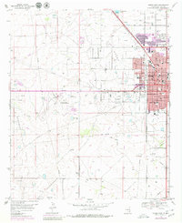
1969 Map of Hobbs West
USGS Topo · Published 1972About this map
Oil production and rapid urban expansion define the landscape of Hobbs during the late 1960s, where a dense network of Oil Wells and a complex Pipeline system crisscross the terrain. The growth of the city is evident in the residential development stretching west toward the Lea County-Hobbs Airport. This survey captures the infrastructure of a booming petroleum economy, including numerous Gravel Pits, a refinery, and a Pumping Sta. Social life and community services are well-represented by landmarks such as the County Hospital, the Bel Aire Shopping Center, and several local education centers like Houston Jr High Sch and Edison Sch. To the south, the settlement of Nadine sits near the Texas-New Mexico border, while the northern reaches include Green Meadow Lake and Memory Gardens (Cem).
Find a feature on this map
61 named features on this map. Tap any name to fly to it.
Don’t see what you’re looking for? This feature index may not catch every label — zoom into the map to look around manually.
Map Details
Editions of this 1969 Hobbs West Map
2 editions found
Other maps of this area

1954 · Hobbs
USGS Topo · 1:250,000

1958 · Hobbs
USGS Topo · 1:250,000

1962 · Lovington
USGS Topo · 1:62,500

1963 · Monument
USGS Topo · 1:62,500

1969 · Humble City
USGS Topo · 1:24,000

1969 · Hobbs SW
USGS Topo · 1:24,000

1969 · Hobbs East
USGS Topo · 1:24,000

1969 · Hobbs SE
USGS Topo · 1:24,000

1969 · Humble City SE
USGS Topo · 1:24,000

1970 · Humble City SE
USGS Topo · 1:24,000