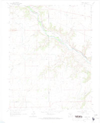
1963 Map of Hobson
USGS Topo · Published 1974About this map
The Arkansas River serves as the primary corridor for movement and utility through this landscape at the boundary of Fremont and Pueblo counties. The Denver and Rio Grande Western railroad tracks follow the northern bank of the river, while an intricate network of water management features, including the Minnequa Canal, Valley Conduit, and Hobson Ditch, divert flow across the arid terrain.
Find a feature on this map
17 named features on this map. Tap any name to fly to it.
Don’t see what you’re looking for? This feature index may not catch every label — zoom into the map to look around manually.
Map Details
Editions of this 1963 Hobson Map
4 editions found
Other maps of this area

1889 · Canon City
USGS Topo · 1:125,000

1891 · Pueblo
USGS Topo · 1:125,000

1892 · Canon City
USGS Topo · 1:125,000

1894 · Pueblo
USGS Topo · 1:125,000

1896 · Pueblo
USGS Topo · 1:125,000

1897 · Pueblo
USGS Topo · 1:125,000

1954 · Pueblo
USGS Topo · 1:250,000

1957 · Pueblo
USGS Topo · 1:250,000

1958 · Pueblo
USGS Topo · 1:250,000

1959 · Florence
USGS Topo · 1:24,000