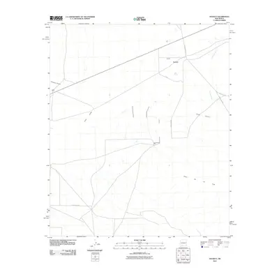
2010 Map of Hockett
USGS Topo · Published 2010About this map
Sierra De Las Uvas dominates the southern landscape of this New Mexico quadrangle, providing a high-desert backdrop to the arid plains of the Uvas Valley. The area is characterized by the intersection of traditional land use and modern agricultural infrastructure, evidenced by landmarks such as the Jones Ranch and Southerland Well. To the north, the small settlement of Hockett sits near the drainage of Placitas Arroyo, which cuts through the high ground. The terrain is defined by rugged drainages including Thirtysix Canyon and Horse Canyon, showing the natural watercourses that have historically shaped movement through this region. A network of rural routes, including Las Uvas Dairy Rd and several numbered county roads, connects isolated ranching interests and water points essential for livestock in this dry environment.
Find a feature on this map
14 named features on this map. Tap any name to fly to it.
Don’t see what you’re looking for? This feature index may not catch every label — zoom into the map to look around manually.
Map Details
Editions of this 2010 Hockett Map
This is the sole edition of this map. No revisions or reprints were ever made.
Other maps of this area

1943 · Corralitos Ranch
USGS Topo · 1:62,500

1955 · Las Cruces
USGS Topo · 1:250,000

1958 · Las Cruces
USGS Topo · 1:250,000

1958 · Arroyo Cuervo
USGS Topo · 1:24,000

1959 · Hatch
USGS Topo · 1:24,000
1959 · Souse Springs
USGS Topo · 1:24,000

1961 · Nutt
USGS Topo · 1:62,500

1972 · Good Sight Peak NE
USGS Topo · 1:24,000

1972 · Good Sight Peak
USGS Topo · 1:24,000

1982 · Hatch
USGS Topo · 1:100,000