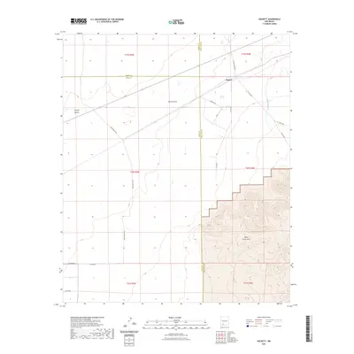
2023 Map of Hockett
USGS Topo · Published 2023About this map
Hockett serves as a central junction point in this high-desert landscape where the borders of Sierra, Luna, and Doña Ana counties converge. The terrain is defined by dramatic elevation changes, rising from the wide drainage of Placitas Arroyo toward the southern heights of the Sierra de las Uvas. This 2023 survey illustrates a modern network of ranching and rural access roads, such as Las Uvas Diary Rd and Hilburn Dr, which cut across the geological features of Horse Canyon and Thirtysix Canyon. The map provides a clear look at the Public Land Survey System grid, including townships like t20s r4w, showing how property and infrastructure are managed in the arid New Mexico interior. The sparse settlement pattern emphasizes the role of named canyons and arroyos as the primary landmarks for navigation and land use in this part of the state.
Find a feature on this map
24 named features on this map. Tap any name to fly to it.
Don’t see what you’re looking for? This feature index may not catch every label — zoom into the map to look around manually.
Map Details
Editions of this 2023 Hockett Map
This is the sole edition of this map. No revisions or reprints were ever made.
Other maps of this area

1943 · Corralitos Ranch
USGS Topo · 1:62,500

1955 · Las Cruces
USGS Topo · 1:250,000

1958 · Las Cruces
USGS Topo · 1:250,000

1958 · Arroyo Cuervo
USGS Topo · 1:24,000

1959 · Hatch
USGS Topo · 1:24,000
1959 · Souse Springs
USGS Topo · 1:24,000

1961 · Nutt
USGS Topo · 1:62,500

1972 · Good Sight Peak NE
USGS Topo · 1:24,000

1972 · Good Sight Peak
USGS Topo · 1:24,000

1982 · Hatch
USGS Topo · 1:100,000