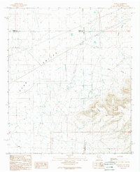
1989 Map of Hockett
USGS Topo · Published 1989About this map
Uvas Valley serves as the central focal point of this arid Chihuahuan Desert landscape where the borders of Sierra, Luna, and Doña Ana counties converge. The sparse settlement of Hockett is situated along a network of unimproved roads and pipelines, marking a remote outpost in a region dominated by drainage patterns and livestock infrastructure. The rugged terrain of the Sierra de las Uvas rises sharply in the southeastern quadrant, defined by steep contours that give way to Horse Canyon and the winding Arroyo Placitas. Water management is the primary human imprint on this land, evidenced by numerous scattered wells, a Tank, and several check dams designed to capture seasonal runoff in a landscape otherwise defined by its desert character.
Find a feature on this map
13 named features on this map. Tap any name to fly to it.
Don’t see what you’re looking for? This feature index may not catch every label — zoom into the map to look around manually.
Map Details
Editions of this 1989 Hockett Map
This is the sole edition of this map. No revisions or reprints were ever made.
Other maps of this area

1943 · Corralitos Ranch
USGS Topo · 1:62,500

1955 · Las Cruces
USGS Topo · 1:250,000

1958 · Las Cruces
USGS Topo · 1:250,000

1958 · Arroyo Cuervo
USGS Topo · 1:24,000

1959 · Hatch
USGS Topo · 1:24,000
1959 · Souse Springs
USGS Topo · 1:24,000

1961 · Nutt
USGS Topo · 1:62,500

1972 · Good Sight Peak NE
USGS Topo · 1:24,000

1972 · Good Sight Peak
USGS Topo · 1:24,000

1982 · Hatch
USGS Topo · 1:100,000