
1996 Map of Hockett
USGS Topo · Published 2002About this map
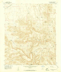
Sierra de las Uvas dominates the southeastern quadrant of this desert landscape, its complex topography rising sharply above the Uvas and Valley floor. The mapping captures a network of resource management and industrial infrastructure, including a prominent Pipeline and a central Sub Sta. The settlement at Hockett serves as a focal point near the intersection of Luna and Doña Ana counties, highlighting the region's historical reliance on seasonal water management via numerous Check Dams, scattered Wells, and isolated Tanks. The presence of a Gravel Pit and numerous WT markers suggests an area shaped by both natural drainage features, like Placitas Arroyo and Horse Canyon, and human efforts to extract and control resources in an arid environment.
Find a feature on this map
16 named features on this map. Tap any name to fly to it.
Don’t see what you’re looking for? This feature index may not catch every label — zoom into the map to look around manually.
Map Details
Editions of this 1996 Hockett Map
This is the sole edition of this map. No revisions or reprints were ever made.
Other maps of this area

1943 · Corralitos Ranch
USGS Topo · 1:62,500

1955 · Las Cruces
USGS Topo · 1:250,000

1958 · Las Cruces
USGS Topo · 1:250,000

1958 · Arroyo Cuervo
USGS Topo · 1:24,000

1959 · Hatch
USGS Topo · 1:24,000
1959 · Souse Springs
USGS Topo · 1:24,000

1961 · Nutt
USGS Topo · 1:62,500

1972 · Good Sight Peak NE
USGS Topo · 1:24,000

1972 · Good Sight Peak
USGS Topo · 1:24,000

1982 · Hatch
USGS Topo · 1:100,000