
1920 Map of Hockley
USGS Topo · Published 1920About this map
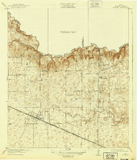
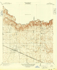
The settlement of Hockley serves as the primary hub of this 1916 survey, situated where the Southern Pacific System and Houston and Texas Central rail lines intersect. The landscape is defined by the headwaters of Kickapoo Creek and Spring Creek, which form the county boundaries for Harris, Waller, and Montgomery. Local industry is anchored by Bauers Sawmill in the north, while the rural interior is dotted with community centers like the Hegar School and Georgia School. The map reveals an early road network including the Magnolia Road and Rose Hill Road, which trace the higher ground between the creek drainages. This preliminary edition highlights the transition from wooded creek bottoms to the open prairie, capturing the early twentieth-century development of these Southeast Texas crossroads before later urbanization.
Find a feature on this map
23 named features on this map. Tap any name to fly to it.
Don’t see what you’re looking for? This feature index may not catch every label — zoom into the map to look around manually.
Map Details
Editions of this 1920 Hockley Map
3 editions found
Other maps of this area

1915 · Cypress
USGS Topo · 1:24,000

1916 · Rose Hill
USGS Topo · 1:24,000

1916 · Hockley
USGS Topo · 1:24,000

1916 · Swanson
USGS Topo · 1:24,000

1918 · Cypress
USGS Topo · 1:31,680

1919 · Swanson
USGS Topo · 1:31,680

1920 · Rose Hill
USGS Topo · 1:31,680

1920 · Waller
USGS Topo · 1:31,680

1950 · Houston
USGS Topo · 1:250,000

1954 · Beaumont
USGS Topo · 1:250,000