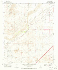
1971 Map of Hodge
USGS Topo · Published 1973About this map
Hodge and Johnstons Corner anchor this San Bernardino County landscape where the Mojave River valley cuts between high desert ranges. The 1971 survey illustrates a critical transportation corridor, dominated by the parallel tracks of the Atchison Topeka and Santa Fe Railway and the Union Pacific, reflecting the region's enduring role as a gateway to the southwest. North of the river, the massive shoulder of Iron Mountain looms over the valley, while the south is defined by the Brisbane Valley and an intricate network of desert access points. These routes, with evocative names like Gunsmoke Road, Frontier Road, and the Chisholm Trail, reveal a mid-century era of recreation and rural land development. The presence of multiple Wells and a large Borrow Pit highlights the logistical demands of maintaining infrastructure in this arid environment before the further expansion of neighboring Barstow.
Find a feature on this map
35 named features on this map. Tap any name to fly to it.
Don’t see what you’re looking for? This feature index may not catch every label — zoom into the map to look around manually.
Map Details
Editions of this 1971 Hodge Map
3 editions found
Other maps of this area

1932 · Barstow
USGS Topo · 1:125,000

1934 · Barstow
USGS Topo · 1:125,000

1953 · San Bernardino
USGS Topo · 1:250,000

1956 · San Bernardino
USGS Topo · 1:250,000

1956 · Hawes
USGS Topo · 1:62,500

1956 · Barstow
USGS Topo · 1:62,500

1956 · Helendale
USGS Topo · 1:24,000
1956 · Victorville
USGS Topo · 1:62,500

1957 · Apple Valley
USGS Topo · 1:62,500

1957 · San Bernardino
USGS Topo · 1:250,000