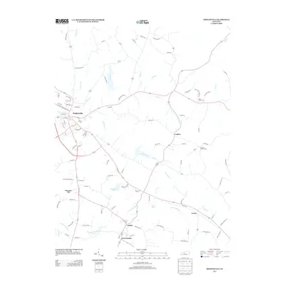
2013 Map of Hodgenville
USGS Topo · Published 2013About this map
The town of Hodgenville serves as the focal point of this LaRue County landscape, where the N Fork Nolin River and S Fork Nolin River converge. The area is defined by a dense network of local roads named for established families, such as Goodin Williams Rd and Logan Skaggs Rd, reflecting a deeply rooted agricultural community. To the south, the settlements of Buffalo and South Buffalo sit near the base of Ferrill Hill, while Boundary Oak marks a significant local landmark on the western edge of the survey.
Find a feature on this map
93 named features on this map. Tap any name to fly to it.
Don’t see what you’re looking for? This feature index may not catch every label — zoom into the map to look around manually.
Map Details
Editions of this 2013 Hodgenville Map
This is the sole edition of this map. No revisions or reprints were ever made.
Other maps of this area

1934 · Munfordville
USGS Topo · 1:48,000

1935 · Elizabethtown
USGS Topo · 1:48,000

1937 · Munfordville
USGS Topo · 1:62,500

1938 · Elizabethtown
USGS Topo · 1:62,500

1949 · Tonieville
USGS Topo · 1:24,000

1949 · Elizabethtown
USGS Topo · 1:24,000
1949 · Elizabethtown
USGS Topo · 1:62,500

1953 · Howardstown
USGS Topo · 1:24,000

1953 · Nelsonville
USGS Topo · 1:24,000

1953 · Hibernia
USGS Topo · 1:24,000