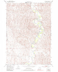
1953 Map of Hoe Ranch
USGS Topo · Published 1984About this map
The Powder River snakes through this high plains landscape, defined by a network of ephemeral drainages and established ranching operations. The map provides a detailed view of livestock-rearing infrastructure during the mid-20th century, notably the Hoe Ranch and Irigaray Ranch. These sites, along with Falxa Camp, highlight the era's reliance on localized water sources such as Hoe Spring and several artesian wells.
Find a feature on this map
17 named features on this map. Tap any name to fly to it.
Don’t see what you’re looking for? This feature index may not catch every label — zoom into the map to look around manually.
Map Details
Editions of this 1953 Hoe Ranch Map
3 editions found
Other maps of this area

1953 · Hoe Ranch
USGS Topo · 1:24,000

1953 · Fort Reno
USGS Topo · 1:24,000

1953 · Fort Reno SE
USGS Topo · 1:24,000

1953 · The Nipple
USGS Topo · 1:24,000

1955 · Sheridan
USGS Topo · 1:250,000

1955 · Arminto
USGS Topo · 1:250,000

1958 · Sheridan
USGS Topo · 1:250,000

1958 · Arminto
USGS Topo · 1:250,000

1961 · Soldier Creek
USGS Topo · 1:24,000

1961 · Provence Ranch
USGS Topo · 1:24,000