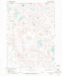
1969 Map of Hog Island
USGS Topo · Published 1972About this map
The Pine Ridge Indian Reservation Boundary defines the northern reaches of this landscape where Cherry and Sheridan counties meet the South Dakota border. The terrain is characterized by an intricate network of wetlands and shallow basins, anchored by the central prominence of Hog Island. Significant water bodies such as Shell Lake, Dads Lake, and Thompson Lake dot the region, illustrating the hydrologic character of the Nebraska Sandhills. Evidence of local water management is visible through the Meadow Horseshoe Ditch, which connects to Alkali Lake in the east. While primarily a natural expanse, small-scale industrial activity is noted at a Sandpit near the western edge. This survey, conducted as part of the Missouri River Basin development program, captures the area's geography just as modern aerial photogrammetry was refining the mapping of these complex shorelines, including family-named landmarks like Mullis Lake and Trucks Lake.
Find a feature on this map
23 named features on this map. Tap any name to fly to it.
Don’t see what you’re looking for? This feature index may not catch every label — zoom into the map to look around manually.
Map Details
Editions of this 1969 Hog Island Map
This is the sole edition of this map. No revisions or reprints were ever made.
Other maps of this area

1950 · Irwin
USGS Topo · 1:62,500

1951 · Irwin
USGS Topo · 1:62,500

1955 · Hot Springs
USGS Topo · 1:250,000

1955 · Alliance
USGS Topo · 1:250,000

1955 · Martin
USGS Topo · 1:250,000

1957 · Alliance
USGS Topo · 1:250,000

1957 · Valentine
USGS Topo · 1:250,000

1958 · Martin
USGS Topo · 1:250,000

1958 · Alliance
USGS Topo · 1:250,000

1959 · Valentine
USGS Topo · 1:250,000