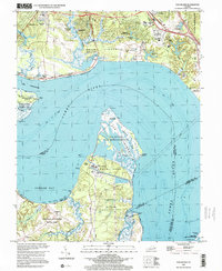
1999 Map of Hog Island
USGS Topo · Published 2001About this map
Jamestown Island and the colonial tidewater landscape dominate this survey of the James River corridor at the close of the twentieth century. The map highlights the complex layering of Virginia's history, from the Kingsmill Plantation Site and Carters Grove Historical Home to the modern energy infrastructure of the Surry Nuclear Powerplant on Gravel Neck. The shoreline is a transition of protected marshlands and historical estates, with the Hog Island State Wildlife Refuge stretching into the river opposite the developed residential areas of Kingsmill On The James. On the southern bank, Chippokes Plantation State Park preserves a traditional agricultural landscape near Cobham. This sheet also captures the leisure and transportation networks of the era, including the Busch Gardens park, the Colonial National Historical Parkway, and the Williamsburg Jamestown Airport.
Find a feature on this map
65 named features on this map. Tap any name to fly to it.
Don’t see what you’re looking for? This feature index may not catch every label — zoom into the map to look around manually.
Map Details
Editions of this 1999 Hog Island Map
This is the sole edition of this map. No revisions or reprints were ever made.
Other maps of this area

1906 · Williamsburg
USGS Topo · 1:62,500

1907 · Yorktown
USGS Topo · 1:62,500

1917 · Toano
USGS Topo · 1:62,500

1918 · Toano
USGS Topo · 1:62,500

1919 · Surry
USGS Topo · 1:62,500

1943 · Yorktown
USGS Topo · 1:62,500

1943 · Richmond
USGS Topo · 1:250,000

1944 · Yorktown
USGS Topo · 1:24,000
1948 · Bacons Castle
USGS Topo · 1:24,000

1949 · Richmond
USGS Topo · 1:250,000