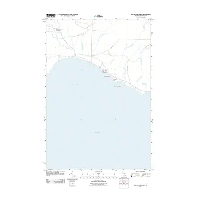
2011 Map of Hog Island Point
USGS Topo · Published 2011About this map
Lake Michigan defines the southern edge of this Upper Peninsula landscape, where numerous tributaries such as Hog Island Creek and Davenport Creek flow through the timberlands toward the coast. The topography reveals a history of land use focused on recreation and conservation, evidenced by the Black River State Forest Campground and the private Harts RV Park near the shoreline. A network of secondary routes and trails, including the Old Stage Trl and Flowing Well Rd, crisscrosses the terrain, indicating older paths of travel through the forest. Along the water's edge, geographical markers like Hog Island Point and Gravel Island stand out as prominent landmarks for navigation and local history. The presence of Garlyn Zoological Park suggests the area's later development as a destination for travelers moving along the northern Great Lakes corridor.
Find a feature on this map
21 named features on this map. Tap any name to fly to it.
Don’t see what you’re looking for? This feature index may not catch every label — zoom into the map to look around manually.
Map Details
Editions of this 2011 Hog Island Point Map
This is the sole edition of this map. No revisions or reprints were ever made.
Other maps of this area

1931 · Epoufette NW
USGS Topo · 1:31,680

1931 · Epoufette SW
USGS Topo · 1:31,680

1931 · Gilchrist NE
USGS Topo · 1:31,680

1931 · Gilchrist NW
USGS Topo · 1:31,680

1954 · Sault Sainte Marie
USGS Topo · 1:250,000

1955 · Hog Island
USGS Topo · 1:62,500

1955 · Cheboygan
USGS Topo · 1:250,000

1956 · Sault Sainte Marie
USGS Topo · 1:250,000

1957 · Sault Sainte Marie
USGS Topo · 1:250,000

1958 · Cheboygan
USGS Topo · 1:250,000