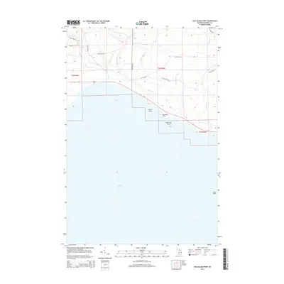
2014 Map of Hog Island Point
USGS Topo · Published 2014About this map
Lake Michigan dominates the southern half of this landscape, its shoreline defined by the prominent Hog Island Point and smaller nearby landforms like Little Hog Island and Gravel Island. Inland, the northern woods of Garfield Township are segmented by a series of south-flowing watercourses, including Borgstrom Cr, the East Br Black River, and Hog Island Cr, all of which eventually drain toward the lake. This 2014 survey documents a territory where modern infrastructure intersects with older transit routes. While Us-2 serves as the primary east-west artery hugging the coast, a network of secondary roads and trails like the Old Stage Trl and Sand Lake Trl suggest a long-standing history of navigation through the dense Upper Peninsula forest. Further out in the lake, the presence of Pelkie Reef indicates the submerged hazards common along this stretch of the Michigan coast.
Find a feature on this map
25 named features on this map. Tap any name to fly to it.
Don’t see what you’re looking for? This feature index may not catch every label — zoom into the map to look around manually.
Map Details
Editions of this 2014 Hog Island Point Map
This is the sole edition of this map. No revisions or reprints were ever made.
Other maps of this area

1931 · Epoufette NW
USGS Topo · 1:31,680

1931 · Epoufette SW
USGS Topo · 1:31,680

1931 · Gilchrist NE
USGS Topo · 1:31,680

1931 · Gilchrist NW
USGS Topo · 1:31,680

1954 · Sault Sainte Marie
USGS Topo · 1:250,000

1955 · Hog Island
USGS Topo · 1:62,500

1955 · Cheboygan
USGS Topo · 1:250,000

1956 · Sault Sainte Marie
USGS Topo · 1:250,000

1957 · Sault Sainte Marie
USGS Topo · 1:250,000

1958 · Cheboygan
USGS Topo · 1:250,000