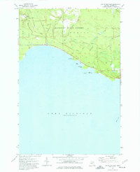
1973 Map of Hog Island Point
USGS Topo · Published 1977About this map
Mackinac State Forest dominates this coastal landscape along the northern shores of Lake Michigan. The terrain is characterized by a network of drainage systems, including the Black River and Sucker Creek, which cut through the timbered interior toward the irregular coastline. Human imprint on the land is reflected in the established transportation corridors like Old Stage Road and Sand Lake Trail, which trace historical routes through the woods. Along the water, Hog Island Point serves as a prominent landmark near Hog Island Campground, while offshore features such as Gravel Island and the submerged Pelkie Reef underscore the navigational complexities of this stretch of the Great Lakes. The presence of a Flowing Well and a Gaging Station on Peters Creek highlights the significance of local hydrology and water management in the early 1970s.
Find a feature on this map
26 named features on this map. Tap any name to fly to it.
Don’t see what you’re looking for? This feature index may not catch every label — zoom into the map to look around manually.
Map Details
Editions of this 1973 Hog Island Point Map
This is the sole edition of this map. No revisions or reprints were ever made.
Other maps of this area

1931 · Epoufette NW
USGS Topo · 1:31,680

1931 · Epoufette SW
USGS Topo · 1:31,680

1931 · Gilchrist NE
USGS Topo · 1:31,680

1931 · Gilchrist NW
USGS Topo · 1:31,680

1954 · Sault Sainte Marie
USGS Topo · 1:250,000

1955 · Hog Island
USGS Topo · 1:62,500

1955 · Cheboygan
USGS Topo · 1:250,000

1956 · Sault Sainte Marie
USGS Topo · 1:250,000

1957 · Sault Sainte Marie
USGS Topo · 1:250,000

1958 · Cheboygan
USGS Topo · 1:250,000