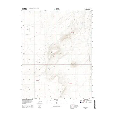
2014 Map of Hogan Mesa
USGS Topo · Published 2014About this map
Hogan Mesa and Casa del Eco Mesa rise above a landscape defined by seasonal drainages and essential desert springs in this 2014 survey. The high tablelands are traversed by specialized routes like Hogan Mesa Rd and Flat Meadows Loop, connecting prominent landmarks such as Standing Rock. Water remains a central feature of the terrain, with Little Water Spring and Salt Water Spring providing vital points of reference along the intermittent flows of Desert Creek and Small Salt Cr.
Find a feature on this map
22 named features on this map. Tap any name to fly to it.
Don’t see what you’re looking for? This feature index may not catch every label — zoom into the map to look around manually.
Map Details
Editions of this 2014 Hogan Mesa Map
This is the sole edition of this map. No revisions or reprints were ever made.
Other maps of this area

1886 · Abajo
USGS Topo · 1:250,000

1892 · Abajo
USGS Topo · 1:250,000

1893 · Abajo
USGS Topo · 1:250,000

1956 · Cortez
USGS Topo · 1:250,000

1958 · Cortez
USGS Topo · 1:250,000

1959 · Cortez
USGS Topo · 1:250,000

1962 · Cortez
USGS Topo · 1:250,000

1962 · Montezuma Creek
USGS Topo · 1:62,500

1962 · Bluff
USGS Topo · 1:62,500
1962 · Boundary Butte
USGS Topo · 1:62,500