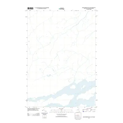
2013 Map of Hogansburg OE N
USGS Topo · Published 2013About this map
The Saint Lawrence River valley near the international border is the focus of this 2013 survey, which highlights the expansive waters of Lake St. Francis. Located near Cornwall, Ontario, and extending into the northern New York borderlands, the map depicts the complex shoreline and seasonal hydrology of this widening in the river system. While the terrain on the New York side is sparsely populated, the map records the network of local roads and drainage patterns that characterize this riverine landscape. The detail focused on Lake St. Francis provides essential data for understanding the historical waterfront and coastal orientation of this cross-border region before modern development or shifts in the Saint Lawrence Seaway.
Find a feature on this map
1 named feature on this map. Tap any name to fly to it.
Don’t see what you’re looking for? This feature index may not catch every label — zoom into the map to look around manually.
Map Details
Editions of this 2013 Hogansburg OE N Map
This is the sole edition of this map. No revisions or reprints were ever made.
Other maps of this area

1906 · Massena
USGS Topo · 1:62,500

1907 · Massena
USGS Topo · 1:62,500

1915 · Moira
USGS Topo · 1:62,500

1917 · Moira
USGS Topo · 1:62,500

1942 · Barnhart Island
USGS Topo · 1:24,000

1943 · Barnhart Island
USGS Topo · 1:31,680

1944 · Moira
USGS Topo · 1:62,500
1946 · Raquette River
USGS Topo · 1:24,000

1948 · Ogdensburg
USGS Topo · 1:250,000

1951 · Ogdensburg
USGS Topo · 1:250,000