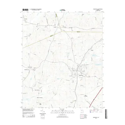
2014 Map of Hogansville
USGS Topo · Published 2014About this map
Hogansville serves as the primary hub on this Troup County landscape, situated at the intersection of Ga-14 and Ga-100. The surrounding terrain is defined by the convergence of the Heard, Coweta, and Troup county lines, creating a junction of local jurisdictions. This survey highlights the dense concentration of local burial grounds and churches that define rural Georgia history, including Walley Chapel Cem, Old Providence Cem, and Myrtle Hill Cem near the town center.
Find a feature on this map
125 named features on this map. Tap any name to fly to it.
Don’t see what you’re looking for? This feature index may not catch every label — zoom into the map to look around manually.
Map Details
Editions of this 2014 Hogansville Map
This is the sole edition of this map. No revisions or reprints were ever made.
Other maps of this area

1899 · Wedowee
USGS Topo · 1:125,000

1902 · Wedowee
USGS Topo · 1:125,000

1953 · Atlanta
USGS Topo · 1:250,000

1957 · Atlanta
USGS Topo · 1:250,000

1958 · Atlanta
USGS Topo · 1:250,000

1964 · Hogansville
USGS Topo · 1:24,000
1964 · Mountville
USGS Topo · 1:24,000
1964 · La Grange
USGS Topo · 1:24,000

1964 · Hillcrest
USGS Topo · 1:24,000

1964 · Grantville
USGS Topo · 1:24,000