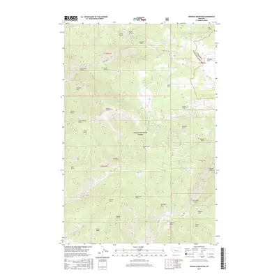
2017 Map of Hogback Mountain
USGS Topo · Published 2017About this map
Helena National Forest dominates this section of the Big Belt Mountains, where the drainage patterns of Beaver Creek and Trout Creek have carved a labyrinth of deep gulches and canyons. The landscape is defined by its dramatic elevation changes, rising toward the summit of Hogback Mountain and the prominent Middleman Mountain. This 2017 survey reveals an intricate network of named geographic features that speak to the area's pioneer and ranching history, from the utilitarian Slaughter Pen Gulch and Blacksmith Gulch to the more evocative Refrigerator Canyon and Checkerboard Gulch. The boundary between Meagher and Lewis and Clark counties cuts through the northeast, passing near Jim Ball Basin and Elk Ridge. To the south, the dramatic Trout Creek Canyon and Vigilante Gulch suggest the difficult terrain that early travelers and miners encountered while navigating these mountain passages.
Find a feature on this map
44 named features on this map. Tap any name to fly to it.
Don’t see what you’re looking for? This feature index may not catch every label — zoom into the map to look around manually.
Map Details
Editions of this 2017 Hogback Mountain Map
This is the sole edition of this map. No revisions or reprints were ever made.
Other maps of this area

1886 · Fort Logan
USGS Topo · 1:250,000

1948 · White Sulphur Springs
USGS Topo · 1:250,000

1950 · Canyon Ferry
USGS Topo · 1:62,500

1950 · East Helena
USGS Topo · 1:62,500

1958 · White Sulphur Springs
USGS Topo · 1:250,000

1961 · White Sulphur Springs
USGS Topo · 1:250,000

1962 · Hogback Mountain
USGS Topo · 1:24,000

1962 · B K Ranch
USGS Topo · 1:24,000
1962 · Middle Creek Lake
USGS Topo · 1:24,000
1962 · Candle Mountain
USGS Topo · 1:24,000