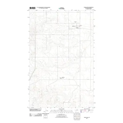
2011 Map of Hogeland
USGS Topo · Published 2011About this map
Hogeland serves as the central hub of this northern Montana landscape, where the town's social and logistical infrastructure is concentrated at the intersection of Hogeland Rd and Hwy 338. Essential local services such as the Hogeland Post Office and the Hogeland Vol Fire Dept are positioned near the center of the settlement, while the Hogeland Airport to the north underscores the connectivity required in this rural expanse. The surrounding terrain is defined by a grid of agricultural and transport corridors including East End Rd and Vadman Rd. The natural topography is shaped by drainage features like Murphy Coulee, with several unimproved paths such as Murray Coulee Rd following the contours of the land, illustrating the persistent relationship between the local road network and the prairie drainage systems.
Find a feature on this map
17 named features on this map. Tap any name to fly to it.
Don’t see what you’re looking for? This feature index may not catch every label — zoom into the map to look around manually.
Map Details
Editions of this 2011 Hogeland Map
This is the sole edition of this map. No revisions or reprints were ever made.
Other maps of this area

1903 · Wayne Creek
USGS Topo · 1:62,500

1905 · Wayne Creek
USGS Topo · 1:62,500

1905 · Harlem
USGS Topo · 1:62,500

1913 · Cherry Ridge
USGS Topo · 1:125,000

1953 · Havre
USGS Topo · 1:250,000

1957 · Havre
USGS Topo · 1:250,000

1958 · Havre
USGS Topo · 1:250,000

1984 · Hogeland SE
USGS Topo · 1:24,000
1984 · Wayne Creek NW
USGS Topo · 1:24,000
1984 · Hogeland
USGS Topo · 1:24,000