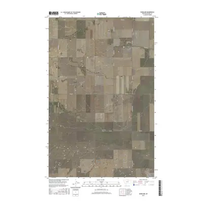
2017 Map of Hogeland
USGS Topo · Published 2017About this map
Hogeland serves as the central hub of this northern Montana landscape, situated near the Canadian border in Blaine County. The small community is organized around Main St and 3rd Ave, with the Hogeland Airport providing a vital connection to this isolated prairie region. The surrounding terrain is defined by a series of geographic depressions and drainage patterns, most notably Murphy Coulee and East Butte Coulee, which snake across the section lines of the Public Land Survey System.
Find a feature on this map
26 named features on this map. Tap any name to fly to it.
Don’t see what you’re looking for? This feature index may not catch every label — zoom into the map to look around manually.
Map Details
Editions of this 2017 Hogeland Map
This is the sole edition of this map. No revisions or reprints were ever made.
Other maps of this area

1903 · Wayne Creek
USGS Topo · 1:62,500

1905 · Wayne Creek
USGS Topo · 1:62,500

1905 · Harlem
USGS Topo · 1:62,500

1913 · Cherry Ridge
USGS Topo · 1:125,000

1953 · Havre
USGS Topo · 1:250,000

1957 · Havre
USGS Topo · 1:250,000

1958 · Havre
USGS Topo · 1:250,000

1984 · Hogeland SE
USGS Topo · 1:24,000
1984 · Wayne Creek NW
USGS Topo · 1:24,000
1984 · Hogeland
USGS Topo · 1:24,000