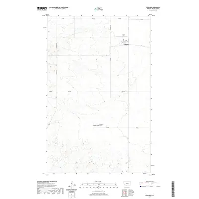
2020 Map of Hogeland
USGS Topo · Published 2020About this map
Hogeland stands as a primary hub for this agricultural landscape in northern Blaine County, characterized by a grid-like network of rural roads that connect isolated farmsteads and production areas. The town center is defined by a modest cluster of streets including Main St and 3rd Ave, supported by the adjacent Hogeland Airport to the northwest. This 2020 survey illustrates a high-plains geography where natural drainage features like Murphy Coulee and East Butte Coulee break the otherwise uniform section lines of the Public Land Survey System. The infrastructure of the area is heavily tied to the local landholders, evidenced by names like Klindworth Rd, Twete Rd, and Billmayer Rd. To the south and east, Murray Coulee Rd follows the winding path of the terrain, contrasting with the straight alignments of Beck Rd and Hogeland Rd.
Find a feature on this map
28 named features on this map. Tap any name to fly to it.
Don’t see what you’re looking for? This feature index may not catch every label — zoom into the map to look around manually.
Map Details
Editions of this 2020 Hogeland Map
This is the sole edition of this map. No revisions or reprints were ever made.
Other maps of this area

1903 · Wayne Creek
USGS Topo · 1:62,500

1905 · Wayne Creek
USGS Topo · 1:62,500

1905 · Harlem
USGS Topo · 1:62,500

1913 · Cherry Ridge
USGS Topo · 1:125,000

1953 · Havre
USGS Topo · 1:250,000

1957 · Havre
USGS Topo · 1:250,000

1958 · Havre
USGS Topo · 1:250,000

1984 · Hogeland SE
USGS Topo · 1:24,000
1984 · Wayne Creek NW
USGS Topo · 1:24,000
1984 · Hogeland
USGS Topo · 1:24,000