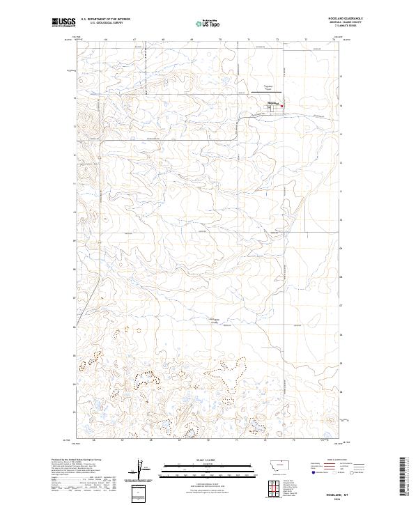
2024 Map of Hogeland
USGS Topo · Published 2024About this map
Hogeland serves as the primary hub for this agricultural landscape in Blaine County, characterized by a meticulous grid of rural roads and the dramatic drainage of East Butte Coulee to the south. The township is oriented around Main St and the Po, supporting the surrounding dryland farming operations and livestock ranches that define the High Line region. Aviation infrastructure is localized at the Hogeland Airport, situated just north of the town center near Poland Rd. This survey documents the intersection of public land systems, specifically where Township 36 North meets Township 35 North, illustrating how section lines dictated the placement of thoroughfares like Twete Rd and Bison Rd. Small depressions and seasonal wetlands dot the sections between Murray Coulee Rd and Hogeland Rd, reflecting the glacial history and drainage patterns of the northern plains.
Find a feature on this map
23 named features on this map. Tap any name to fly to it.
Don’t see what you’re looking for? This feature index may not catch every label — zoom into the map to look around manually.
Map Details
Editions of this 2024 Hogeland Map
This is the sole edition of this map. No revisions or reprints were ever made.
Other maps of this area

1903 · Wayne Creek
USGS Topo · 1:62,500

1905 · Wayne Creek
USGS Topo · 1:62,500

1905 · Harlem
USGS Topo · 1:62,500

1913 · Cherry Ridge
USGS Topo · 1:125,000

1953 · Havre
USGS Topo · 1:250,000

1957 · Havre
USGS Topo · 1:250,000

1958 · Havre
USGS Topo · 1:250,000

1984 · Hogeland SE
USGS Topo · 1:24,000
1984 · Wayne Creek NW
USGS Topo · 1:24,000
1984 · Hogeland
USGS Topo · 1:24,000