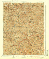
1926 Map of Holbrook
USGS Topo · Published 1942About this map
The Staunton and Parkersburg Pike cuts through the southern portion of this landscape, serving as a primary corridor for travel through the hills of West Virginia in the mid-1920s. This survey, revised by E.I. Ireland, captures a rural society deeply connected by a dense network of one-room schoolhouses and country churches. The terrain is defined by the three branches of the Hughes River, with the Middle Fork and South Fork carving deep valleys that dictated the placement of small communities like Auburn and Coxs Mills. This map reveals the heavy distribution of local education, featuring dozens of named facilities such as the Lower Whiteoak School and Upper Otterslide School. For genealogists, the map provides precise locations for landmark ridges like Beason Ridge and remote settlements including Newberne and Burnt House, illustrating the 19th-century settlement patterns that persisted into the early 20th century.
Find a feature on this map
113 named features on this map. Tap any name to fly to it.
Don’t see what you’re looking for? This feature index may not catch every label — zoom into the map to look around manually.
Map Details
Editions of this 1926 Holbrook Map
2 editions found

Other maps of this area

1893 · Sutton
USGS Topo · 1:125,000

1904 · Vadis
USGS Topo · 1:62,500

1905 · Centerpoint
USGS Topo · 1:62,500

1905 · West Union
USGS Topo · 1:62,500

1906 · Saint Marys
USGS Topo · 1:62,500

1906 · Holbrook
USGS Topo · 1:62,500

1906 · Glenville
USGS Topo · 1:62,500

1906 · Burnsville
USGS Topo · 1:62,500

1907 · Harrisville
USGS Topo · 1:62,500

1907 · Arnoldsburg
USGS Topo · 1:62,500