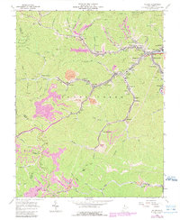
1963 Map of Holden
USGS Topo · Published 1989About this map
Island Creek and its many tributaries carve through the coal-rich hills of Logan County, defining a landscape of narrow hollows and concentrated industrial settlements. This 1963 survey, updated with 1986 aerial data, reveals the density of the region's mining heritage through numerous strip mines and mine dumps that flank communities like Whitman, Holden, and Verdunville. The spiritual and social life of these mountain towns is marked by landmarks such as the Coal Miners Chapel and Mount Olive Ch, while genealogists can locate family burial sites including Avis Cem and Ferrell Cem. The Chessy System railroad provides the vital industrial backbone for the area, following the creek beds to transport coal. To the north, the Chief Logan State Recreation Area offers a glimpse into the early development of regional public lands amidst the active extraction economy of the mid-to-late 20th century.
Find a feature on this map
99 named features on this map. Tap any name to fly to it.
Don’t see what you’re looking for? This feature index may not catch every label — zoom into the map to look around manually.
Map Details
Editions of this 1963 Holden Map
3 editions found
Other maps of this area

1887 · Warfield
USGS Topo · 1:125,000

1891 · Oceana
USGS Topo · 1:125,000

1891 · Warfield
USGS Topo · 1:125,000

1893 · Oceana
USGS Topo · 1:125,000

1898 · Oceana
USGS Topo · 1:125,000

1909 · Matewan
USGS Topo · 1:48,000

1909 · Gilbert
USGS Topo · 1:48,000

1910 · Holden
USGS Topo · 1:48,000

1912 · Gilbert
USGS Topo · 1:62,500

1912 · Holden
USGS Topo · 1:62,500