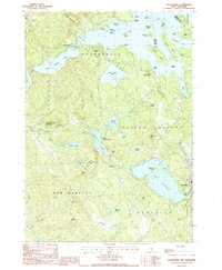
1987 Map of Holderness
USGS Topo · Published 1987About this map
Squam Lake dominates this central New Hampshire landscape, its complex shoreline defined by points and islands like Great Island and Kimball Island. The 1980s terrain shows a deeply interconnected water system, where Little Squam Lake and White Oak Pond sit alongside smaller upland bodies like Sky Pond and Hawkins Pond. This survey captures the region as a recreational and residential hub, with Holderness and Meredith serving as primary anchors. Significant elevation changes are marked by Cotton Mountain and Shepard Hill, while the Sky Pond State Forest preserves a large tract of wooded interior. Local history is etched into the map through numerous small Cem sites and family-named landmarks such as Dolloff Hill and McGrillis Hill, alongside infrastructure like the Golf Course and a Sandpit reflecting the modern economy of the late 20th century.
Find a feature on this map
64 named features on this map. Tap any name to fly to it.
Don’t see what you’re looking for? This feature index may not catch every label — zoom into the map to look around manually.
Map Details
Editions of this 1987 Holderness Map
This is the sole edition of this map. No revisions or reprints were ever made.
Other maps of this area

1909 · Winnepesaukee
USGS Topo · 1:62,500

1925 · Holderness
USGS Topo · 1:62,500

1927 · Holderness
USGS Topo · 1:62,500

1928 · Plymouth
USGS Topo · 1:62,500

1931 · Plymouth
USGS Topo · 1:62,500

1931 · Mt. Chocorua
USGS Topo · 1:62,500

1949 · Portland
USGS Topo · 1:250,000

1956 · Winnipesaukee
USGS Topo · 1:62,500

1956 · Holderness
USGS Topo · 1:62,500

1956 · Portland
USGS Topo · 1:250,000