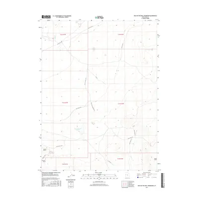
2017 Map of Hole-in-the-Wall Reservoir
USGS Topo · Published 2017About this map
Hole-in-the-Wall Reservoir sits at the center of this arid landscape in Juab County, where water management and ranching access define the geography. The terrain is marked by the volcanic textures of Smelter Knolls to the southwest and the rising slopes of the Confusion Range and Middle Range. This 2017 survey details a network of named tracks and loops essential for navigation in the West Desert, including Granite Ranch Rd and Hole In The Well Reservoir Rd. Small water features like Granite Cr appear in the northern sections, while the map's naming conventions, such as the Confusion Cutoff, reflect the challenging orientation of this remote high-desert basin. The survey preserves the precise alignment of range and township lines, providing a clear view of how these vast public lands are partitioned for management.
Find a feature on this map
22 named features on this map. Tap any name to fly to it.
Don’t see what you’re looking for? This feature index may not catch every label — zoom into the map to look around manually.
Map Details
Editions of this 2017 Hole-in-the-Wall Reservoir Map
This is the sole edition of this map. No revisions or reprints were ever made.
Other maps of this area

1908 · Fish Springs
USGS Topo · 1:250,000

1910 · Fish Springs
USGS Topo · 1:250,000

1953 · Delta
USGS Topo · 1:250,000

1958 · Delta
USGS Topo · 1:250,000

1960 · Granite Mountain
USGS Topo · 1:62,500

1961 · Trout Creek
USGS Topo · 1:62,500

1962 · Delta
USGS Topo · 1:250,000

1972 · Mud Lake Reservoir
USGS Topo · 1:24,000
1972 · Boyd Station
USGS Topo · 1:24,000
1972 · Indian Farm Creek
USGS Topo · 1:24,000