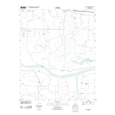
2011 Map of Holla Bend
USGS Topo · Published 2011About this map
Holla Bend dominates this riverine landscape where the Arkansas River carves a deep loop through the fertile lowlands of Pope County. The geography is defined by its relationship to the water, featuring the Point Bar Cutoff and several significant meanders like Howells Bend and Neelys Bend. This area serves as a vital corridor between the growing community of Pottsville to the north and the agricultural expanses of Carden Bottoms to the south. Numerous family and community burial grounds, including the Shinn Cemetery, Bethel Cemetery, and Pearson Cemetery, are scattered across the terrain, offering essential clues for genealogists tracking early settlers. The eastern portion is anchored by the Galla Creek Wildlife Lake, while smaller settlements such as Bethel, New Hope, and Lakeview mark the historic crossroads and residential clusters that have long relied on this river valley.
Find a feature on this map
85 named features on this map. Tap any name to fly to it.
Don’t see what you’re looking for? This feature index may not catch every label — zoom into the map to look around manually.
Map Details
Editions of this 2011 Holla Bend Map
This is the sole edition of this map. No revisions or reprints were ever made.
Other maps of this area

1888 · Dardanelle #4
USGS Topo · 1:62,500

1888 · Dardanelle #1
USGS Topo · 1:62,500

1889 · Morrilton No. 3
USGS Topo · 1:62,500

1890 · Dardanelle
USGS Topo · 1:125,000

1892 · Morrillton
USGS Topo · 1:125,000

1894 · Morrillton
USGS Topo · 1:125,000

1956 · Russellville
USGS Topo · 1:250,000

1961 · Adona
USGS Topo · 1:24,000

1961 · Atkins
USGS Topo · 1:24,000
1962 · Moreland
USGS Topo · 1:24,000