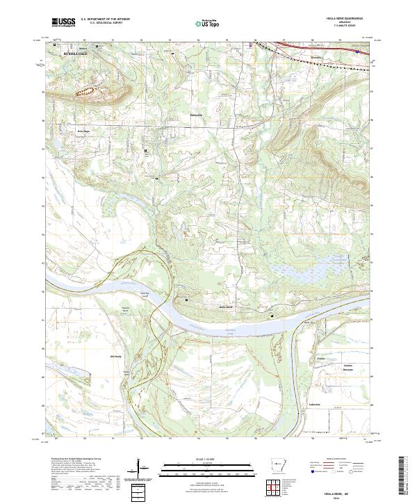
2024 Map of Holla Bend
USGS Topo · Published 2024About this map
Holla Bend National Wildlife Refuge dominates the bend of the Arkansas River, preserving a landscape of oxbows and river bottoms south of Pottsville. This 2024 survey captures the distinct geography created by the Holla Bend Cutoff, which isolated the land that now serves as a significant sanctuary. The map reveals a dense concentration of local history through its many small burial grounds, including Pisgah Cem, Dunn Springs Cem, and the Pearson Cem, which are scattered among the agricultural lands and creek drainages. To the north, the southern edges of Russellville and the heights of Carrion Crow Mtn provide a vertical contrast to the low-lying Carden Bottoms. Notable transportation and settlement markers like Reeds Ferry and Old Neely point to the area's long-standing connection to the river's path and the rural road networks that serve these Pope and Yell County communities.
Find a feature on this map
114 named features on this map. Tap any name to fly to it.
Don’t see what you’re looking for? This feature index may not catch every label — zoom into the map to look around manually.
Map Details
Editions of this 2024 Holla Bend Map
This is the sole edition of this map. No revisions or reprints were ever made.
Other maps of this area

1888 · Dardanelle #4
USGS Topo · 1:62,500

1888 · Dardanelle #1
USGS Topo · 1:62,500

1889 · Morrilton No. 3
USGS Topo · 1:62,500

1890 · Dardanelle
USGS Topo · 1:125,000

1892 · Morrillton
USGS Topo · 1:125,000

1894 · Morrillton
USGS Topo · 1:125,000

1956 · Russellville
USGS Topo · 1:250,000

1961 · Adona
USGS Topo · 1:24,000

1961 · Atkins
USGS Topo · 1:24,000
1962 · Moreland
USGS Topo · 1:24,000