
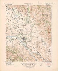
1940 Map of Hollister
USGS Topo · Published 1940About this map
Hollister serves as the central hub of this 1940 tactical map, situated at the crossroads of a developing agricultural valley and the Southern Pacific rail line. The landscape is defined by the San Benito River and the broad alluvial plains of the Llano Del Santa Clara Valley and Bolsa De San Felipe. The presence of numerous small educational institutions, such as Anasymas School, San Justo School, and Fairview School, alongside family-named holdings like Pacheco Ranch and Swanson Ranch, indicates a dispersed rural population supported by local ranching and farming operations. To the southeast, the settlement of Tres Pinos marks the rail terminus near Bolado Park, while infrastructure like the Hollister Airport and County Hospital reflect the growing civic needs of San Benito County just before the mid-century.
Find a feature on this map
62 named features on this map. Tap any name to fly to it.
Don’t see what you’re looking for? This feature index may not catch every label — zoom into the map to look around manually.
Map Details
Editions of this 1940 Hollister Map
2 editions found
Other maps of this area

1910 · Salinas
USGS Topo · 1:31,680

1912 · Salinas
USGS Topo · 1:62,500

1915 · San Juan Bautista
USGS Topo · 1:48,000

1917 · Morgan Hill
USGS Topo · 1:62,500

1917 · San Juan Bautista
USGS Topo · 1:62,500

1919 · San Benito
USGS Topo · 1:62,500

1919 · Hollister
USGS Topo · 1:48,000

1920 · Pacheco Pass
USGS Topo · 1:62,500

1921 · Gonzales
USGS Topo · 1:62,500

1921 · Gilroy Hot Springs
USGS Topo · 1:62,500