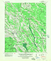
1940 Map of Holly Grove
USGS Topo · Published 1954About this map
Holly Grove serves as the focal point of this Arkansas Delta landscape, situated at the intersection of the Arkansas Midland RR and the Missouri Pacific RR. The map reveals a densely settled rural network characterized by numerous combined community spaces, such as Whitehall Ch & Sch and Mt Olive Ch & Sch, reflecting an era when local schools and churches were the primary social anchors. The topography is defined by the complex hydrology of the White River basin, featuring the Warrior Bottom and the Mattock Bay oxbow, which dictated the placement of early settlements like Pine City and Lawrenceville. Unique landmarks such as the Boat Gunwale Bridge and several specialized rail sidings like Chimi Spur and Hauselman Spur illustrate a localized economy dependent on timber and agricultural transport during the 1930s and 1940s.
Find a feature on this map
93 named features on this map. Tap any name to fly to it.
Don’t see what you’re looking for? This feature index may not catch every label — zoom into the map to look around manually.
Map Details
Editions of this 1940 Holly Grove Map
2 editions found
Other maps of this area

1935 · Clarendon
USGS Topo · 1:62,500

1939 · Modoc
USGS Topo · 1:62,500

1939 · Indian Bay
USGS Topo · 1:62,500

1940 · Marvell
USGS Topo · 1:62,500

1940 · Holly Grove
USGS Topo · 1:62,500

1940 · Brinkley
USGS Topo · 1:62,500

1940 · Marianna
USGS Topo · 1:62,500

1941 · De Witt
USGS Topo · 1:62,500

1941 · De Valls Bluff
USGS Topo · 1:62,500

1941 · Clarendon
USGS Topo · 1:62,500