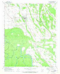
1971 Map of Holly Grove
USGS Topo · Published 1973About this map
The town of Holly Grove serves as the focal point for this 1970s landscape, positioned along the Missouri Pacific railroad. The surrounding terrain is defined by a complex network of waterways, including Dial Creek, Walker Cypress Creek, and Boat Gunwale Slash. To the south, the environment shifts toward more significant water bodies like Maddox Bay and Upper Eagle Nest Lake, bordered by the prominent Bluff Cut.
Find a feature on this map
39 named features on this map. Tap any name to fly to it.
Don’t see what you’re looking for? This feature index may not catch every label — zoom into the map to look around manually.
Map Details
Editions of this 1971 Holly Grove Map
This is the sole edition of this map. No revisions or reprints were ever made.
Other maps of this area

1935 · Clarendon
USGS Topo · 1:62,500

1939 · Indian Bay
USGS Topo · 1:62,500

1940 · Holly Grove
USGS Topo · 1:62,500

1941 · De Witt
USGS Topo · 1:62,500

1941 · Clarendon
USGS Topo · 1:62,500

1948 · Helena
USGS Topo · 1:250,000

1950 · Helena
USGS Topo · 1:250,000

1954 · Indian Bay
USGS Topo · 1:62,500

1954 · De Witt
USGS Topo · 1:62,500

1955 · Helena
USGS Topo · 1:250,000