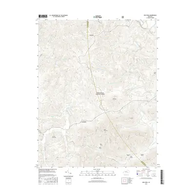
2016 Map of Hollyhill
USGS Topo · Published 2016About this map
The Daniel Boone National Forest dominates this McCreary County landscape, where the settlements of Hollyhill and Duckrun are situated among a complex network of ridges and deep drainage basins. The area is defined by the sharp relief of local peaks such as Ryans Creek Mtn and Granny Holt Knob, while the intricate topography of the Cumberland Plateau is evidenced by numerous named hollows, including Chitwood Hollow and Rube Hollow. These narrow valleys descend toward significant watercourses like Marsh Creek and Jellico Creek. The presence of the Laurel Cem near the western edge and various family-named landmarks provides valuable points of interest for those studying the local genealogy and land use patterns within this heavily forested region of Kentucky.
Find a feature on this map
44 named features on this map. Tap any name to fly to it.
Don’t see what you’re looking for? This feature index may not catch every label — zoom into the map to look around manually.
Map Details
Editions of this 2016 Hollyhill Map
This is the sole edition of this map. No revisions or reprints were ever made.
Other maps of this area

1890 · Williamsburg
USGS Topo · 1:125,000

1894 · Williamsburg
USGS Topo · 1:125,000

1952 · Wofford
USGS Topo · 1:24,000

1952 · Hollyhill
USGS Topo · 1:24,000

1952 · Wiborg
USGS Topo · 1:24,000

1952 · Cumberland Falls
USGS Topo · 1:24,000

1952 · Williamsburg
USGS Topo · 1:24,000

1952 · Whitley City
USGS Topo · 1:24,000
1953 · Winfield
USGS Topo · 1:24,000
1953 · Jellico West
USGS Topo · 1:24,000