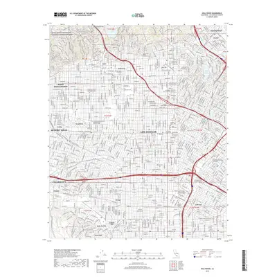
2018 Map of Hollywood
USGS Topo · Published 2018About this map
Hollywood and its surrounding urban centers are captured in high detail, showcasing the region's concentration of cultural and educational institutions. The map highlights the dense street network extending from W Sunset Blvd and Hollywood Blvd, connecting the Santa Monica Mountains to the residential and commercial hubs of West Hollywood and Beverly Hills. Major landmarks of the film and music industries are present, including the American Film Institute Conservatory and the Los Angeles Film School. Historical burial grounds like Hollywood Forever Cem and Beth Olam Cem sit near the center of the sheet, while the northern edge is defined by the Cahuenga Pass and the water supply infrastructure of Silver Lake Reservoir. The south is anchored by Leimert Park and the campus of the Univ of Southern California, illustrating the diverse layout of modern Los Angeles.
Find a feature on this map
67 named features on this map. Tap any name to fly to it.
Don’t see what you’re looking for? This feature index may not catch every label — zoom into the map to look around manually.
Map Details
Editions of this 2018 Hollywood Map
This is the sole edition of this map. No revisions or reprints were ever made.
Other maps of this area

1894 · Los Angeles
USGS Topo · 1:62,500

1896 · Pasadena
USGS Topo · 1:62,500

1896 · Redondo
USGS Topo · 1:62,500

1896 · Santa Monica
USGS Topo · 1:62,500

1896 · Downey
USGS Topo · 1:62,500

1898 · Santa Monica
USGS Topo · 1:62,500

1899 · Downey
USGS Topo · 1:62,500

1900 · Pasadena
USGS Topo · 1:62,500

1900 · Los Angeles
USGS Topo · 1:62,500

1901 · Southern California Sheet No. 1
USGS Topo · 1:250,000