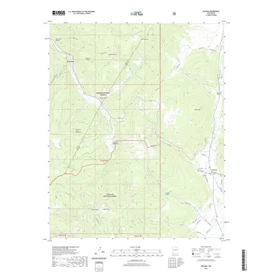
2020 Map of Holman
USGS Topo · Published 2020About this map
The Sangre de Cristo Mountains and Santa Fe Mountains dominate this 2020 landscape, where the rugged peaks of the Carson National Forest meet the Santa Fe National Forest. The settlement of Holman serves as a local hub near the Mora River, marked by several burial grounds including Holman Presbyterian Cem and San Isidro Cem. Further west, the small community of Angostura sits along the Rito Angostura at the foot of Angostura Ridge. A network of historic irrigation and water management is visible through features like the La Sierra Ditch and the flowing waters of Rio Pueblo and Agua Fria Cr. This map documents a high-altitude territory defined by deep canyons such as Osha Canyon and the high plateaus of Walker Flats.
Find a feature on this map
61 named features on this map. Tap any name to fly to it.
Don’t see what you’re looking for? This feature index may not catch every label — zoom into the map to look around manually.
Map Details
Editions of this 2020 Holman Map
This is the sole edition of this map. No revisions or reprints were ever made.
Other maps of this area

1889 · Las Vegas
USGS Topo · 1:125,000

1889 · Santa Fe
USGS Topo · 1:125,000

1891 · Las Vegas
USGS Topo · 1:125,000

1893 · Las Vegas
USGS Topo · 1:125,000

1894 · Santa Fe
USGS Topo · 1:125,000

1954 · Santa Fe
USGS Topo · 1:250,000

1954 · Raton
USGS Topo · 1:250,000

1958 · Raton
USGS Topo · 1:250,000

1958 · Santa Fe
USGS Topo · 1:250,000
1963 · Pecos Falls
USGS Topo · 1:24,000