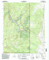
1995 Map of Holman
USGS Topo · Published 1998About this map
The Sangre de Cristo Mountains dominate this landscape where the boundaries of the Santa Barbara Grant and Mora Grant intersect. The settlement of Holman sits in the southeastern valley, adjacent to the Agua Negra Cemetery and the flowing Mora River. High-altitude irrigation is evidenced by the Sierra Ditch and La Sierra Ditch, engineered waterways that trace the contours of the mountain slopes to support agriculture in this arid environment.
Find a feature on this map
47 named features on this map. Tap any name to fly to it.
Don’t see what you’re looking for? This feature index may not catch every label — zoom into the map to look around manually.
Map Details
Editions of this 1995 Holman Map
This is the sole edition of this map. No revisions or reprints were ever made.
Other maps of this area

1889 · Las Vegas
USGS Topo · 1:125,000

1889 · Santa Fe
USGS Topo · 1:125,000

1891 · Las Vegas
USGS Topo · 1:125,000

1893 · Las Vegas
USGS Topo · 1:125,000

1894 · Santa Fe
USGS Topo · 1:125,000

1954 · Santa Fe
USGS Topo · 1:250,000

1954 · Raton
USGS Topo · 1:250,000

1958 · Raton
USGS Topo · 1:250,000

1958 · Santa Fe
USGS Topo · 1:250,000
1963 · Pecos Falls
USGS Topo · 1:24,000