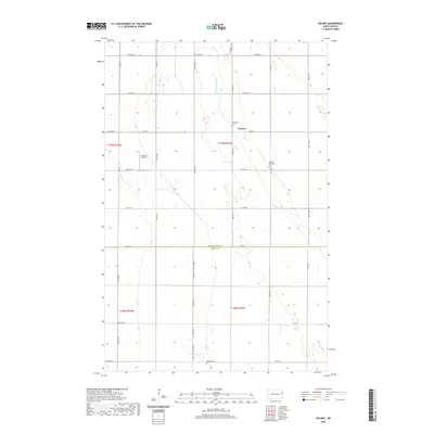
2020 Map of Holmes
USGS Topo · Published 2020About this map
Holmes serves as the quiet center of this agricultural landscape in eastern North Dakota, situated just north of the Grand Forks and Traill County line. The map reveals a deeply rooted rural community, evidenced by several scattered burial grounds including Stjordalen Cemetery and Holmes Methodist Cemetery. These small markers represent the legacy of early settlers in the Red River Valley region. Drainage and irrigation are central to the terrain here, defined by engineered waterways like Drain Number 28 and the natural path of Cole Creek. Further west, the Gensrich Airport provides a modern point of interest amidst a grid of section roads like County Road 22 and County Highway 14, which facilitate the movement of grain and equipment across the vast prairie farmlands.
Find a feature on this map
25 named features on this map. Tap any name to fly to it.
Don’t see what you’re looking for? This feature index may not catch every label — zoom into the map to look around manually.
Map Details
Editions of this 2020 Holmes Map
This is the sole edition of this map. No revisions or reprints were ever made.
Other maps of this area

1934 · Emerado
USGS Topo · 1:48,000

1934 · Grand Forks
USGS Topo · 1:62,500

1936 · Emerado
USGS Topo · 1:62,500

1938 · Grand Forks
USGS Topo · 1:62,500

1952 · Grand Forks
USGS Topo · 1:250,000

1956 · Grand Forks
USGS Topo · 1:250,000

1963 · Emerado SE
USGS Topo · 1:24,000

1963 · Emerado SW
USGS Topo · 1:24,000

1966 · Grand Forks
USGS Topo · 1:250,000
1970 · Hatton
USGS Topo · 1:24,000