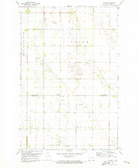
1971 Map of Holmes
USGS Topo · Published 1973About this map
The small settlement of Holmes sits at the heart of this agricultural landscape along the border of Grand Forks and Traill Counties. Surveyed in the early 1970s, the terrain is defined by a precise section-line road grid that services a network of remote farmsteads and rural community centers. Local heritage is concentrated at sites like Holmes Ch and Bethany Ch, while the Bethany Cem and another Cem near the county line offer valuable points of interest for genealogical research. The land is largely open, punctuated by seasonal drainage and the winding path of Cole Creek. Specialized landmarks of the era include the Gensrich Landing Field, a localized Townhall, and a Radio Tower (WDAY) that signals the area's connection to wider regional broadcasts. Scattered Gravel Pit operations indicate the local extraction industry supporting the township road system.
Find a feature on this map
17 named features on this map. Tap any name to fly to it.
Don’t see what you’re looking for? This feature index may not catch every label — zoom into the map to look around manually.
Map Details
Editions of this 1971 Holmes Map
This is the sole edition of this map. No revisions or reprints were ever made.
Other maps of this area

1934 · Emerado
USGS Topo · 1:48,000

1934 · Grand Forks
USGS Topo · 1:62,500

1936 · Emerado
USGS Topo · 1:62,500

1938 · Grand Forks
USGS Topo · 1:62,500

1952 · Grand Forks
USGS Topo · 1:250,000

1956 · Grand Forks
USGS Topo · 1:250,000

1963 · Emerado SE
USGS Topo · 1:24,000

1963 · Emerado SW
USGS Topo · 1:24,000

1966 · Grand Forks
USGS Topo · 1:250,000
1970 · Hatton
USGS Topo · 1:24,000