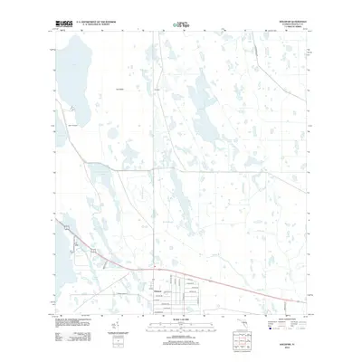
2012 Map of Holopaw
USGS Topo · Published 2012About this map
Holopaw anchors the southern portion of this landscape, where a grid of residential streets like Satellite Ave, Apollo Ave, and Mercury Dr reflects the era's aerospace influences. The surrounding terrain is a complex network of wetlands and intermittent water bodies, including Grape Hammock Slough, Hogpen Slough, and Myrtle Slough, which dominate the central and western sections. To the north, the geography shifts toward larger open waters such as Lake Conlin and Cat Lake, the latter situated near the Lake X Airport. Smaller features like Cat Island and Tohopkee are interspersed among numerous bays and ponds like John H Bay and Rocky Pond. This survey details a transition from the structured residential blocks of the settlement into an expansive natural drainage system defined by named tributaries like Indian Br and N Br Crabgrass Cr.
Find a feature on this map
39 named features on this map. Tap any name to fly to it.
Don’t see what you’re looking for? This feature index may not catch every label — zoom into the map to look around manually.
Map Details
Editions of this 2012 Holopaw Map
This is the sole edition of this map. No revisions or reprints were ever made.
Other maps of this area

1953 · Holopaw SE
USGS Topo · 1:24,000

1953 · Narcoossee SE
USGS Topo · 1:24,000

1953 · Narcoossee
USGS Topo · 1:24,000

1953 · Deer Park NW
USGS Topo · 1:24,000

1953 · Holopaw SW
USGS Topo · 1:24,000

1953 · Lake Poinsett SW
USGS Topo · 1:24,000

1953 · Deer Park
USGS Topo · 1:24,000

1953 · Ashton
USGS Topo · 1:24,000

1953 · Holopaw
USGS Topo · 1:24,000

1955 · Orlando
USGS Topo · 1:250,000