
1953 Map of Holopaw SW
USGS Topo · Published 1954About this map
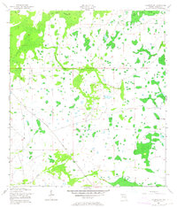
Big Bend Swamp and Lonesome Swamp dominate this central Florida landscape, revealing a period when much of Osceola County remained an intricate network of wetlands and seasonal drainages. The influence of the timber or early agricultural industries is evident in the presence of an Old Railroad Grade and an Old RR Grade that cut through the southern and eastern sectors, suggesting a legacy of resource extraction in what was then a largely unpopulated interior.
Find a feature on this map
11 named features on this map. Tap any name to fly to it.
Don’t see what you’re looking for? This feature index may not catch every label — zoom into the map to look around manually.
Map Details
Editions of this 1953 Holopaw SW Map
3 editions found
Other maps of this area

1952 · Lake Weohyakapka NE
USGS Topo · 1:24,000

1953 · Lake Marian NW
USGS Topo · 1:24,000

1953 · Cypress Lake
USGS Topo · 1:24,000

1953 · Holopaw SE
USGS Topo · 1:24,000

1953 · St Cloud South
USGS Topo · 1:24,000

1953 · Ashton
USGS Topo · 1:24,000

1953 · Holopaw
USGS Topo · 1:24,000

1953 · Lake Marian NE
USGS Topo · 1:24,000

1955 · Orlando
USGS Topo · 1:250,000

1956 · Fort Pierce
USGS Topo · 1:250,000