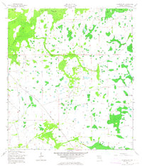
1953 Map of Holopaw SW
USGS Topo · Published 1964About this map
Big Bend Swamp and Lonesome Camp Swamp dominate this interior Florida landscape, reflecting the hydrological character of Osceola County in the early 1950s. The area is defined by a complex network of seasonal watercourses and wetlands, including the winding path of Canoe Creek and the southern reaches of Hog Pen Slough.
Find a feature on this map
11 named features on this map. Tap any name to fly to it.
Don’t see what you’re looking for? This feature index may not catch every label — zoom into the map to look around manually.
Map Details
Editions of this 1953 Holopaw SW Map
3 editions found
Other maps of this area

1952 · Lake Weohyakapka NE
USGS Topo · 1:24,000

1953 · Lake Marian NW
USGS Topo · 1:24,000

1953 · Cypress Lake
USGS Topo · 1:24,000

1953 · Holopaw SE
USGS Topo · 1:24,000

1953 · St Cloud South
USGS Topo · 1:24,000

1953 · Holopaw SW
USGS Topo · 1:24,000

1953 · Ashton
USGS Topo · 1:24,000

1953 · Holopaw
USGS Topo · 1:24,000

1953 · Lake Marian NE
USGS Topo · 1:24,000

1955 · Orlando
USGS Topo · 1:250,000