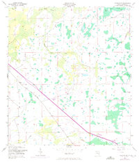
1953 Map of Holopaw SW
USGS Topo · Published 1972About this map
Big Bend Swamp and Lonesome Camp Swamp dominate this interior landscape of Osceola County, showing the complex drainage patterns of Central Florida in the mid-20th century. The land is defined by water and past industry, where Hog Pen Slough and Scrub Slough wind through the terrain. A notable modernization appears in purple photorevisions, as Floridas Turnpike Toll Road cuts a sharp diagonal across the drainage basins of Canoe Creek and Bull Creek. This transition period is further evidenced by the lingering traces of the area's timber or ranching past, marked by an Old Railroad Grade and Old RR Grade that parallel the eastern edge of the survey area. The presence of these grades alongside the newer toll road illustrates the shift from early rail-based resource extraction to modern automotive infrastructure.
Find a feature on this map
10 named features on this map. Tap any name to fly to it.
Don’t see what you’re looking for? This feature index may not catch every label — zoom into the map to look around manually.
Map Details
Editions of this 1953 Holopaw SW Map
3 editions found
Other maps of this area

1952 · Lake Weohyakapka NE
USGS Topo · 1:24,000

1953 · Lake Marian NW
USGS Topo · 1:24,000

1953 · Cypress Lake
USGS Topo · 1:24,000

1953 · Holopaw SE
USGS Topo · 1:24,000

1953 · St Cloud South
USGS Topo · 1:24,000

1953 · Holopaw SW
USGS Topo · 1:24,000

1953 · Ashton
USGS Topo · 1:24,000

1953 · Holopaw
USGS Topo · 1:24,000

1953 · Lake Marian NE
USGS Topo · 1:24,000

1955 · Orlando
USGS Topo · 1:250,000