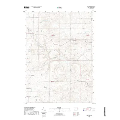
2018 Map of Holy Cross
USGS Topo · Published 2018About this map
Holy Cross and its surrounding Dubuque County settlements appear in high detail at the edge of the Driftless Area. The landscape is carved by the N Fork Little Maquoketa River and the Middle Fork Little Maquoketa River, which define the drainage patterns between the ridgetop towns. For genealogists, the map is remarkably dense with burial grounds, including the Holy Cross Catholic Cem, Saint Clement Catholic Cem, and the Cottage Hill Protestant Cem. Smaller communities like Bankston, Cottage Hill, and Rickardsville are linked by a complex network of local routes such as Garlow Valley Ln and Bankston Park Rd, reflecting the enduring rural infrastructure of these hill-country townships. The concentration of Catholic and Protestant cemeteries near these villages highlights the distinct ethnic and religious settlement patterns common to this part of eastern Iowa.
Find a feature on this map
63 named features on this map. Tap any name to fly to it.
Don’t see what you’re looking for? This feature index may not catch every label — zoom into the map to look around manually.
Map Details
Editions of this 2018 Holy Cross Map
This is the sole edition of this map. No revisions or reprints were ever made.
Other maps of this area

1900 · Anamosa
USGS Topo · 1:125,000

1900 · Lancaster
USGS Topo · 1:125,000

1901 · Peosta
USGS Topo · 1:125,000

1902 · Elkader
USGS Topo · 1:125,000

1904 · Lancaster
USGS Topo · 1:125,000

1908 · Lancaster
USGS Topo · 1:125,000

1955 · Cassville
USGS Topo · 1:24,000

1955 · Balltown
USGS Topo · 1:24,000

1956 · Sherrill
USGS Topo · 1:24,000

1957 · Turkey River
USGS Topo · 1:24,000