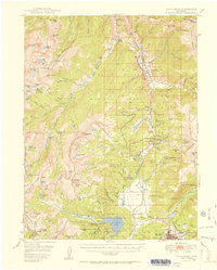
1951 Map of Holy Cross
USGS Topo · Published 1951About this map
The Continental Divide zigzags across this high-altitude landscape, separating the headwaters of the Eagle and Arkansas rivers. Much of the northern terrain is occupied by the Military Reservation surrounding Camp Hale and Pando, established as the training ground for the 10th Mountain Division. The infrastructure of the Denver and Rio Grande Western railroad tracks the valley floor, passing through Deen and Mitchell before crossing the divide at Tennessee Pass.
Find a feature on this map
113 named features on this map. Tap any name to fly to it.
Don’t see what you’re looking for? This feature index may not catch every label — zoom into the map to look around manually.
Map Details
Editions of this 1951 Holy Cross Map
2 editions found

Other maps of this area

1889 · Leadville
USGS Topo · 1:125,000

1891 · Leadville
USGS Topo · 1:125,000

1909 · Mount Jackson
USGS Topo · 1:125,000

1911 · Mount Jackson
USGS Topo · 1:125,000

1929 · Dillon
USGS Topo · 1:62,500

1934 · Climax
USGS Topo · 1:48,000

1934 · Minturn
USGS Topo · 1:62,500

1934 · Dillon
USGS Topo · 1:62,500

1935 · Mount Elbert
USGS Topo · 1:62,500

1938 · Mt. Lincoln
USGS Topo · 1:48,000