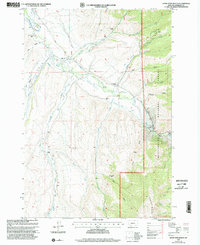
1997 Map of Home Park Ranch
USGS Topo · Published 2002About this map
Ruby River meanders through the heart of this Madison County landscape, flanked by a complex network of agricultural irrigation channels such as Larrabee Ditch, Peterson Ditch, and Galloway Ditch. This 1997 revision of a 1961 survey depicts a rural environment defined by dispersed family ranching and public land management. Settled locations like Home Park Ranch, Gilbert Ranch, and Battle Ranch reflect the enduring livestock heritage of the region, while smaller sites like Hale Place and Tate Place provide specific points of interest for genealogists tracing homesteading history. To the east, the terrain rises into the Beaverhead National Forest, reaching toward the heights of Snowcrest Mountain. The map serves as a detailed record of the intersection between private ranching operations and federal forest lands, marked by isolation and a reliance on the river's water for sustainability.
Find a feature on this map
51 named features on this map. Tap any name to fly to it.
Don’t see what you’re looking for? This feature index may not catch every label — zoom into the map to look around manually.
Map Details
Editions of this 1997 Home Park Ranch Map
This is the sole edition of this map. No revisions or reprints were ever made.
Other maps of this area

1888 · Three Forks
USGS Topo · 1:250,000

1893 · Dillon
USGS Topo · 1:250,000

1894 · Three Forks
USGS Topo · 1:250,000

1895 · Three Forks
USGS Topo · 1:250,000

1947 · Bozeman
USGS Topo · 1:250,000

1948 · Bozeman
USGS Topo · 1:250,000

1949 · Varney
USGS Topo · 1:62,500

1950 · Monument Ridge
USGS Topo · 1:62,500

1955 · Bozeman
USGS Topo · 1:250,000

1955 · Dubois
USGS Topo · 1:250,000