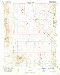
1956 Map of Homer Mtn
USGS Topo · Published 1963About this map
Fort Piute (Ruins) and nearby Petroglyphs stand as significant cultural markers in this desert landscape along the Old Government Road. This mid-century survey documents the transition between the high Piute Range and the expansive Piute Valley, where water sources like Piute Spring were critical for historical travel. The map clearly delineates the Von Schmidt Line, the original 1873 border survey between California and Nevada, which cuts diagonally across the terrain of the Dead Mountains and Newberry Mountains. Small-scale mining activity is evident through the Juniper Mine and scattered shafts, while the northeastern corner shows the boundary of the Lake Mead National Recreational Area. The network of Jeep Trails and unnamed trails crossing Piute Wash illustrates the region's 1950s accessibility for mineral exploration and desert passage.
Find a feature on this map
21 named features on this map. Tap any name to fly to it.
Don’t see what you’re looking for? This feature index may not catch every label — zoom into the map to look around manually.
Map Details
Editions of this 1956 Homer Mtn Map
4 editions found
Other maps of this area

1886 · Camp Mohave
USGS Topo · 1:250,000

1892 · Camp Mohave
USGS Topo · 1:250,000

1903 · Needles
USGS Topo · 1:125,000

1904 · Needles Special
USGS Topo · 1:125,000

1910 · Ivanpah
USGS Topo · 1:250,000

1912 · Ivanpah
USGS Topo · 1:250,000

1926 · Mohave City
USGS Topo · 1:96,000

1942 · Camp Mohave
USGS Topo · 1:250,000

1942 · Ivanpah
USGS Topo · 1:250,000

1942 · Amboy
USGS Topo · 1:250,000