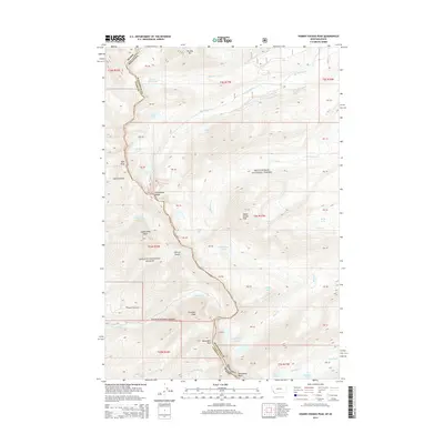
2014 Map of Homer Youngs Peak
USGS Topo · Published 2014About this map
The Continental Divide forms a sharp natural boundary through this high-altitude landscape, separating the Beaverhead National Forest in Montana from the Salmon National Forest in Idaho. This 2014 survey documents the complex hydrological patterns of the Bitterroot Range, where numerous glacial cirque lakes such as Slag-a-melt Lakes, Rock Island Lakes, and Albino Lake feed into diverging drainage systems. To the west, the N Fork Kirtley Cr and E Fork Kirtley Cr flow toward the Salmon River, while to the east, waters from Kelly Cr and Little Lake Cr contribute to the Big Hole River basin. Significant summits including Homer Youngs Peak, Sacajawea Peaks, and Ajax Peak provide the primary landmarks for this largely roadless area, with Freeman Creek Rd serving as one of the few managed access points into the backcountry.
Find a feature on this map
39 named features on this map. Tap any name to fly to it.
Don’t see what you’re looking for? This feature index may not catch every label — zoom into the map to look around manually.
Map Details
Editions of this 2014 Homer Youngs Peak Map
This is the sole edition of this map. No revisions or reprints were ever made.
Other maps of this area
1950 · Salmon
USGS Topo · 1:62,500
1951 · Salmon
USGS Topo · 1:62,500

1955 · Dillon
USGS Topo · 1:250,000
1956 · Goldstone Mtn
USGS Topo · 1:62,500

1957 · Dillon
USGS Topo · 1:250,000

1958 · Dillon
USGS Topo · 1:250,000

1962 · Dillon
USGS Topo · 1:250,000
1965 · Dillon
USGS Topo · 1:250,000
1966 · Badger Spring Gulch
USGS Topo · 1:24,000
1966 · Shewag Lake
USGS Topo · 1:24,000