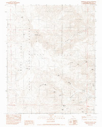
1982 Map of Homewood Canyon
USGS Topo · Published 1983About this map
The Argus Range dominates this landscape, where the rugged terrain of Inyo County meets the restricted boundaries of the China Lake Naval Weapons Center. This 1982 provisional survey captures a high-desert environment defined by its scarce water sources and mining history. Vital reliable water points like La Motte Spring, Quail Spring, and Margaret Ann Spring are scattered across the slopes, supporting both the local ecosystem and the prospectors who once worked these canyons.
Find a feature on this map
32 named features on this map. Tap any name to fly to it.
Don’t see what you’re looking for? This feature index may not catch every label — zoom into the map to look around manually.
Map Details
Editions of this 1982 Homewood Canyon Map
This is the sole edition of this map. No revisions or reprints were ever made.
Other maps of this area

1908 · Ballarat
USGS Topo · 1:250,000

1913 · Ballarat
USGS Topo · 1:250,000

1915 · Searles Lake
USGS Topo · 1:250,000

1947 · Trona
USGS Topo · 1:250,000

1948 · Trona
USGS Topo · 1:250,000

1948 · Death Valley
USGS Topo · 1:250,000

1949 · Trona
USGS Topo · 1:62,500

1950 · Trona
USGS Topo · 1:62,500

1951 · Maturango Peak
USGS Topo · 1:62,500

1951 · Coso Peak
USGS Topo · 1:62,500