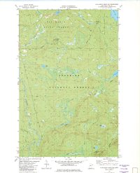
1981 Map of Honeymoon Mountain
USGS Topo · Published 1982About this map
Pat Bayle State Forest and the Superior National Forest define this corner of the North Shore highlands during the early 1980s. The landscape is dominated by the ridges of the Sawtooth Mountains, including notable heights like Honeymoon Mountain and Oberg Mountain. A complex network of water moves through the timber, from the winding Temperance River and Onion River to secluded basins like Pancore Lake and Frisk Lake.
Find a feature on this map
29 named features on this map. Tap any name to fly to it.
Don’t see what you’re looking for? This feature index may not catch every label — zoom into the map to look around manually.
Map Details
Editions of this 1981 Honeymoon Mountain Map
This is the sole edition of this map. No revisions or reprints were ever made.
Other maps of this area

1919 · Brule Lake
USGS Topo · 1:62,500

1919 · Lutsen
USGS Topo · 1:62,500

1954 · Two Harbors
USGS Topo · 1:250,000

1955 · Tofte
USGS Topo · 1:24,000

1955 · Schroeder
USGS Topo · 1:24,000

1955 · Tofte
USGS Topo · 1:62,500

1957 · Two Harbors
USGS Topo · 1:250,000

1958 · Two Harbors
USGS Topo · 1:250,000

1959 · Lutsen
USGS Topo · 1:24,000

1960 · Tait Lake
USGS Topo · 1:24,000