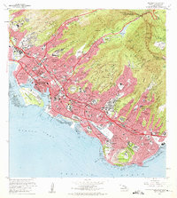
1969 Map of Honolulu
USGS Topo · Published 1975About this map
Diamond Head and the volcanic crater of Punchbowl define the dramatic topography of this coastal landscape as it appeared in the late 1960s. The urban sprawl of Honolulu is shown in transition, with the Lunalilo Freeway and Pali Highway cutting through established neighborhoods like Kaimuki and Kalihi Kai. The map documents a dense network of educational and military institutions, from the sprawling University of Hawaii campus and Kamehameha Schools to the tactical footprints of Fort Shafter Military Reservation and Fort Ruger. Along the waterfront, the maritime economy is visible through the engineering of the Kapalama Basin, Honolulu Harbor, and the iconic Ala Wai Canal bordering Waikiki. From the peaks of the Koolau Range to the coral reefs of Mamala Bay, this survey provides a precise record of the city's mid-century footprint.
Find a feature on this map
147 named features on this map. Tap any name to fly to it.
Don’t see what you’re looking for? This feature index may not catch every label — zoom into the map to look around manually.
Map Details
Editions of this 1969 Honolulu Map
2 editions found
Other maps of this area

1952 · Koko Head
USGS Topo · 1:24,000

1952 · Mokapu
USGS Topo · 1:24,000

1953 · Honolulu
USGS Topo · 1:24,000

1953 · Puuloa
USGS Topo · 1:24,000

1954 · Oahu
USGS Topo · 1:250,000

1954 · Kaneohe
USGS Topo · 1:24,000

1954 · Waipahu
USGS Topo · 1:24,000

1959 · Mokapu
USGS Topo · 1:24,000

1959 · Koko Head
USGS Topo · 1:24,000

1959 · Kaneohe
USGS Topo · 1:24,000